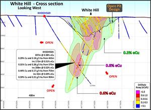
Cross section through the White Hill deposit showing KHDDH569.
Cross section through the White Hill deposit showing KHDDH569.
Figure 2
Zaraa cross section showing KHDDH570.
Zaraa cross section showing KHDDH570.
Figure 3
Plan view of Stockwork Hill (mineralisation projected to surface) showing the distribution of mineralisation and interaction between grade and structure in the bornite zone. Current Target Zones are highlighted and drill hole KHDDH571.
Plan view of Stockwork Hill (mineralisation projected to surface) showing the distribution of mineralisation and interaction between grade and structure in the bornite zone. Current Target Zones are highlighted and drill hole KHDDH571.
Figure 4
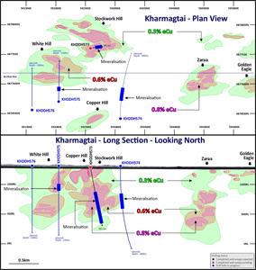
Kharmagtai District Map showing current drill holes.
Kharmagtai District Map showing current drill holes.
Figure 5
Kharmagtai District Long Section - Known Mineralisation
Kharmagtai District Long Section - Known Mineralisation
Figure 6
Core Slab KHDDH573
Core Slab KHDDH573
Figure 7
Core Slab KHDDH574
Core Slab KHDDH574
TORONTO, July 13, 2021 (GLOBE NEWSWIRE) -- Xanadu Mines Ltd (ASX: XAM, TSX: XAM) (Xanadu or the Company) is pleased to update the market on its on-going exploration program for porphyry copper and gold deposits at the Kharmagtai District in the South Gobi region of Mongolia.
Highlights
Large scale extension to known mineralisation at White Hill, with drill hole KHDDH569 returning 697m @ 0.38% eCu from 443m, including 172m @ 0.51% eCu from 570m and 208m @ 0.52% eCu from 754m.
KHDDH569 successfully extends the southern flank of the White Hill deposit by 300m and represents a material increase in tonnage over the current resource.
KHDDH570 completes Zaraa resource drilling, with work commencing on a maiden mineral resource estimate for Q4 of 2021.
Stockwork Hill drill hole KHDDH571 passes between higher grade bornite compartments on Fifty-Fifty Fault, revising high-grade targeting program.
In progress drill hole KHDDH574 between White Hill and Zaraa has entered visible porphyry mineralisation and may represent a new discovery.
Three rigs operating, testing extensions to White Hill and Zaraa and high-grade zones at Stockwork Hill.
Continuing three-prong strategy of discovery, high grade definition and resource expansion.
Xanadu’s Chief Executive Officer, Dr Andrew Stewart, said “June delivered significant results. At White Hill, KHDDH569 added more than 300m of mineralisation to the south, which is a significant increase in copper tonnage and moves Xanadu closer to our >1 billion tonne objective. At Stockwork Hill, KHDDH571 indicates the high-grade Bornite zone has a larger offset on either side of the Fifty-Fifty fault, which refines our models as we zero in on our >100 million tonne high grade objective.”
Assay results are returned for three diamond drill holes. Full intercepts and drill hole details can be found in Appendix 1, Tables 1 and 2.
Drill Hole KHDDH569 (White Hill)
KHDDH569 was drilled targeting the southern extensions of the White Hill deposit. The hole encountered mineralisation over 300m outside the current mineral resource estimate boundary and has returned a significant 697m intercept (Figure 1).
Drill hole KHDDH570 was drilled on the eastern margin of the Zaraa deposit to complete the data acquisition for the maiden mineral resource estimate for Zaraa. KHDDH570 encountered over 700m of mineralisation and returned the following intercept (Figure 2).
Drill hole KHDDH571 was drilled targeting the western compartment of the bornite zone where previous drill holes suggested the bornite zone extended (Figure 3). In plan view, the bornite zone appears to be offset by the 50:50 fault and the western compartment steps to the north. The bornite zone appears to form in two compartments split by a fault (50:50 fault).
KHDDH571 encountered a broad shallow zone of low-grade mineralisation, similar to that associated with White Hill, and only 28m of moderate grade mineralisation associated with the bornite zone. This suggests that the offset to the bornite zone on the west of the 50:50 fault is larger than anticipated. Modelling is underway to understand this relationship.
KHDDH573 at Stockwork Hill is currently targeting the up and down-dip extensions of the high-grade bornite zone. This hole is currently at 750m and has passed through 230m of strong (visual) mineralisation below the 50:50 fault (Figure 6).
Drilling has commenced on KHDDH574, a discovery drill hole targeting mineralisation between White Hill and Zaraa. KHDDH574 is currently at 850m and entered porphyry mineralisation at 550m. Mineralisation consists of porphyry B-veins and disseminated chalcopyrite (Figure 7). This is a significant advance for the Kharmagtai project and may represent a new discovery.
At White Hill a second drill hole (KHDDH575) has been collared to extend the mineralisation there to the south. This hole is currently at 200m and mineralisation is anticipated from 390m.
Exploration Program
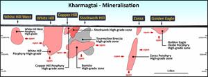
Xanadu’s goal is to target an increase of the combined Kharmagtai mineral resource to >1 billion tonnes @ ≥0.5% copper equivalent (eCu) including >100 million tonnes @ ≥0.8% eCu, aiming to enable future development of the Kharmagtai District.
The drilling program at Kharmagtai is designed around this goal, with a three prong strategy including:
High-Grade Definition Program – define scale and tenor of gold-rich, bornite zones identified underneath current Stockwork Hill, White Hill and Copper Hill mineral resources;
Discovery Drilling Program – drilling of priority targets to identify new discoveries on the Kharmagtai District; and
Resource Upgrade Program – define to Indicated status deeper mineralisation beneath the current mineral resource and large-scale mineralisation at Zaraa.
Xanadu is an ASX and TSX listed Exploration company operating in Mongolia. We give investors exposure to globally significant, large scale copper-gold discoveries and low-cost inventory growth. Xanadu maintains a portfolio of exploration projects and remains one of the few junior explorers on the ASX or TSX who control a globally significant copper-gold deposit in our flagship Kharmagtai project. For information on Xanadu visit: www.xanadumines.com.
This Announcement was authorised for release by Xanadu’s Board of Directors.
Appendix 1: Drilling Results
Table 1: Drill hole collar
Hole ID
Prospect
East
North
RL
Azimuth (°)
Inc (°)
Depth (m)
KHDDH569
White Hill
591766
4876609
1314
0
-60
1,270.0
KHDDH570
Zaraa
594727
4877204
1271
197
-65
1,051.3
KHDDH571
Stockwork Hill
592455
4877275
1295
0
-65
1,021.6
Table 2: Significant drill results
Hole ID
Prospect
From (m)
To (m)
Interval (m)
Au (g/t)
Cu (%)
eCu (%)
eAu (g/t)
KHDDH569
White Hill
200
220
20
0.08
0.07
0.11
0.21
and
298.3
304
5.7
0.05
0.09
0.12
0.23
and
314
326
12
0.03
0.06
0.08
0.15
and
340
366
26
0.05
0.06
0.09
0.17
and
443
1140
697
0.18
0.29
0.38
0.74
including
503
508
5
0.12
0.31
0.37
0.73
including
570
742
172
0.38
0.31
0.51
1.00
including
653
664.5
11.5
0.33
0.63
0.80
1.56
including
754
962
208
0.17
0.44
0.52
1.02
including
794
800.3
6.3
0.18
0.56
0.65
1.28
including
811
843
32
0.22
0.62
0.73
1.42
including
815
819
4
0.27
0.89
1.03
2.01
including
904
946
42
0.21
0.59
0.69
1.35
including
972
1032
60
0.15
0.35
0.43
0.84
including
990
1012
22
0.24
0.47
0.59
1.15
and
1152
1188
36
0.05
0.13
0.16
0.31
and
1218
1228
10
0.05
0.19
0.21
0.42
and
1238
1248
10
0.03
0.08
0.10
0.19
and
1258
1267.7
9.7
0.03
0.08
0.09
0.18
KHDDH570
Zaraa
203
209
6
0.07
0.06
0.10
0.20
and
227
302
75
0.08
0.08
0.12
0.24
and
318.5
1022
703.5
0.17
0.19
0.28
0.54
including
455
461
6
0.21
0.27
0.38
0.73
including
489
497
8
0.19
0.24
0.34
0.66
including
507
517
10
0.20
0.20
0.31
0.60
including
539
547
8
0.16
0.21
0.29
0.56
including
557
753.1
196.1
0.25
0.25
0.38
0.74
including
736
740
4
0.63
0.47
0.80
1.56
including
763
866
103
0.30
0.23
0.39
0.75
including
779.8
792
12.2
0.65
0.22
0.56
1.09
including
828
836
8
0.48
0.51
0.75
1.46
including
885
895
10
0.28
0.31
0.45
0.88
including
909
951
42
0.13
0.24
0.31
0.60
and
1035
1051.3
16.3
0.03
0.13
0.15
0.28
KHDDH571
Stockwork Hill
3
464
461
0.07
0.15
0.19
0.37
including
3
15
12
0.22
0.28
0.40
0.78
including
25
41
16
0.12
0.22
0.28
0.55
including
51
65
14
0.14
0.23
0.30
0.59
including
177
183
6
0.10
0.25
0.31
0.60
including
246
258
12
0.11
0.16
0.22
0.42
and
682.3
752
69.7
0.13
0.22
0.28
0.55
including
718
746
28
0.18
0.31
0.40
0.79
and
818
846
28
0.13
0.06
0.13
0.25
including
836
844
8
0.21
0.16
0.27
0.53
and
862
866
4
0.12
0.12
0.17
0.34
and
896
906
10
0.05
0.05
0.07
0.15
Appendix 2: Statements and Disclaimers
Mineral Resources and Ore Reserves Reporting Requirements
The 2012 Edition of the Australasian Code for Reporting of Exploration Results, Mineral Resources and Ore Reserves (the JORC Code 2012) sets out minimum standards, recommendations and guidelines for Public Reporting in Australasia of Exploration Results, Mineral Resources and Ore Reserves. The Information contained in this Announcement has been presented in accordance with the JORC Code 2012.
The Company is not aware of any new, material information or data that is not included in those market announcements.
Competent Person Statement
The information in this announcement that relates to exploration results is based on information compiled by Dr Andrew Stewart, who is responsible for the exploration data, comments on exploration target sizes, QA/QC and geological interpretation and information. Dr Stewart, who is an employee of Xanadu and is a Member of the Australasian Institute of Geoscientists, has sufficient experience relevant to the style of mineralisation and type of deposit under consideration and to the activity he is undertaking to qualify as the “Competent Person” as defined in the 2012 Edition of the Australasian Code for Reporting Exploration Results, Mineral Resources and Ore Reserves and the National Instrument 43-101. Dr Stewart consents to the inclusion in the report of the matters based on this information in the form and context in which it appears.
Copper Equivalent Calculations
The copper equivalent (CuEq or eCu) calculation represents the total metal value for each metal, multiplied by the conversion factor, summed and expressed in equivalent copper percentage with a metallurgical recovery factor applied. The copper equivalent calculation used is based off the eCu calculation defined by CSA in the 2018 Mineral Resource Upgrade (see ASX Announcement dated 31 October 2018).
Copper equivalent grade values were calculated using the formula eCu = Cu + Au * 0.62097 * 0.8235.
Where Cu = copper grade (%); Au = gold grade (gold per tonne (g/t)); 0.62097 = conversion factor (gold to copper); and 0.8235 = relative recovery of gold to copper (82.35%).
These equivalent formulas were based on the following parameters (prices are in USD): Copper price = 3.1 $/lb (or 6,834 $ per tonne ($/t)); Gold price = 1,320 $ per ounce ($/oz); Copper recovery = 85%; Gold recovery = 70%; and Relative recovery of gold to copper = 70% / 85% = 82.35%.
Forward-Looking Statements
Certain statements contained in this Announcement, including information as to the future financial or operating performance of Xanadu and its projects may also include statements which are ‘forward‐looking statements’ that may include, amongst other things, statements regarding targets, estimates and assumptions in respect of mineral reserves and mineral resources and anticipated grades and recovery rates, production and prices, recovery costs and results, capital expenditures and are or may be based on assumptions and estimates related to future technical, economic, market, political, social and other conditions. These ‘forward-looking statements’ are necessarily based upon a number of estimates and assumptions that, while considered reasonable by Xanadu, are inherently subject to significant technical, business, economic, competitive, political and social uncertainties and contingencies and involve known and unknown risks and uncertainties that could cause actual events or results to differ materially from estimated or anticipated events or results reflected in such forward‐looking statements.
Xanadu disclaims any intent or obligation to update publicly or release any revisions to any forward‐looking statements, whether as a result of new information, future events, circumstances or results or otherwise after the date of this Announcement or to reflect the occurrence of unanticipated events, other than required by the Corporations Act 2001 (Cth) and the Listing Rules of the Australian Securities Exchange (ASX) and Toronto Stock Exchange (TSX). The words ‘believe’, ‘expect’, ‘anticipate’, ‘indicate’, ‘contemplate’, ‘target’, ‘plan’, ‘intends’, ‘continue’, ‘budget’, ‘estimate’, ‘may’, ‘will’, ‘schedule’ and similar expressions identify forward‐looking statements.
All ‘forward‐looking statements’ made in this Announcement are qualified by the foregoing cautionary statements. Investors are cautioned that ‘forward‐looking statements’ are not guarantee of future performance and accordingly investors are cautioned not to put undue reliance on ‘forward‐looking statements’ due to the inherent uncertainty therein.
For further information please visit the Xanadu Mines’ Website at www.xanadumines.com.
Appendix 3: Kharmagtai Table 1 (JORC 2012)
Set out below is Section 1 and Section 2 of Table 1 under the JORC Code, 2012 Edition for the Kharmagtai project. Data provided by Xanadu. This Table 1 updates the JORC Table 1 disclosure dated 11 April 2019.
JORC TABLE 1 - SECTION 1 - SAMPLING TECHNIQUES AND DATA
(Criteria in this section apply to all succeeding sections).
Criteria
JORC Code explanation
Commentary
Sampling techniques
Nature and quality of sampling (e.g. cut channels, random chips, or specific specialised industry standard measurement tools appropriate to the minerals under investigation, such as down hole gamma sondes, or handheld XRF instruments, etc.). These examples should not be taken as limiting the broad meaning of sampling.
Include reference to measures taken to ensure sample representivity and the appropriate calibration of any measurement tools or systems used.
Aspects of the determination of mineralisation that are Material to the Public Report.
In cases where ‘industry standard’ work has been done this would be relatively simple (e.g. ‘reverse circulation drilling was used to obtain 1m samples from which 3kg was pulverised to produce a 30g charge for fire assay’). In other cases, more explanation may be required, such as where there is coarse gold that has inherent sampling problems. Unusual commodities or mineralisation types (e.g. submarine nodules) may warrant disclosure of detailed information.
Representative ½ core samples were split from PQ, HQ & NQ diameter diamond drill core on site using rock saws, on a routine 2m sample interval that also honours lithological/intrusive contacts.
The orientation of the cut line is controlled using the core orientation line ensuring uniformity of core splitting wherever the core has been successfully oriented.
Sample intervals are defined and subsequently checked by geologists, and sample tags are attached (stapled) to the plastic core trays for every sample interval.
Reverse Circulation (RC) chip samples are ¼ splits from one meter (1m) intervals using a 75%:25% riffle splitter to obtain a 3kg sample
RC samples are uniform 2m samples formed from the combination of two ¼ split 1m samples.
Drilling techniques
Drill type (e.g. core, reverse circulation, open-hole hammer, rotary air blast, auger, Bangka, sonic, etc.) and details (e.g. core diameter, triple or standard tube, depth of diamond tails, face-sampling bit or other type, whether core is oriented and if so, by what method, etc.).
The Mineral Resource estimation has been based upon diamond drilling of PQ, HQ and NQ diameters with both standard and triple tube core recovery configurations, RC drilling and surface trenching with channel sampling.
All drill core drilled by Xanadu has been oriented using the “Reflex Ace” tool.
Drill sample recovery
Method of recording and assessing core and chip sample recoveries and results assessed.
Measures taken to maximise sample recovery and ensure representative nature of the samples.
Whether a relationship exists between sample recovery and grade and whether sample bias may have occurred due to preferential loss/gain of fine/coarse material.
Diamond drill core recoveries were assessed using the standard industry (best) practice which involves: removing the core from core trays; reassembling multiple core runs in a v-rail; measuring core lengths with a tape measure, assessing recovery against core block depth measurements and recording any measured core loss for each core run.
Diamond core recoveries average 97% through mineralization.
Overall, core quality is good, with minimal core loss. Where there is localized faulting and or fracturing core recoveries decrease, however, this is a very small percentage of the mineralized intersections.
RC recoveries are measured using whole weight of each 1m intercept measured before splitting
Analysis of recovery results vs grade shows no significant trends that might indicate sampling bias introduced by variable recovery in fault/fracture zones.
Logging
Whether core and chip samples have been geologically and geotechnically logged to a level of detail to support appropriate Mineral Resource estimation, mining studies and metallurgical studies.
Whether logging is qualitative or quantitative in nature. Core (or costean, channel, etc.) photography.
The total length and percentage of the relevant intersections logged.
All drill core is geologically logged by well-trained geologists using a modified “Anaconda-style” logging system methodology. The Anaconda method of logging and mapping is specifically designed for porphyry Cu-Au mineral systems and is entirely appropriate to support Mineral Resource Estimation, mining and metallurgical studies.
Logging of lithology, alteration and mineralogy is intrinsically qualitative in nature. However, the logging is subsequently supported by 4 Acid ICP-MS (48 element) geochemistry and SWIR spectral mineralogy (facilitating semi-quantitative/calculated mineralogical, lithological and alteration classification) which is integrated with the logging to improve cross section interpretation and 3D geological model development.
Drill core is also systematically logged for both geotechnical features and geological structures. Where drill core has been successfully oriented, the orientation of structures and geotechnical features are also routinely measured.
Both wet and dry core photos are taken after core has been logged and marked-up but before drill core has been cut.
Sub-sampling techniques and sample preparation
If core, whether cut or sawn and whether quarter, half or all core taken.
If non-core, whether riffled, tube sampled, rotary split, etc. and whether sampled wet or dry.
For all sample types, the nature, quality and appropriateness of the sample preparation technique.
Quality control procedures adopted for all sub-sampling stages to maximise representivity of samples.
Measures taken to ensure that the sampling is representative of the in-situ material collected, including for instance results for field duplicate/second-half sampling.
Whether sample sizes are appropriate to the grain size of the material being sampled.
All drill core samples are ½ core splits from either PQ, HQ or NQ diameter cores. A routine 2m sample interval is used, but this is varied locally to honour lithological/intrusive contacts. The minimum allowed sample length is 30cm.
Core is appropriately split (onsite) using diamond core saws with the cut line routinely located relative to the core orientation line (where present) to provide consistency of sample split selection.
The diamond saws are regularly flushed with water to minimize potential contamination.
A field duplicate ¼ core sample is collected every 30th sample to ensure the “representivity of the in-situ material collected”. The performance of these field duplicates is routinely analysed as part of Xanadu’s sample QC process.
Routine sample preparation and analyses of DDH samples were carried out by ALS Mongolia LLC (ALS Mongolia), who operates an independent sample preparation and analytical laboratory in Ulaanbaatar.
All samples were prepared to meet standard quality control procedures as follows: Crushed to 75% passing 2mm, split to 1kg, pulverised to 85% passing 200 mesh (75 microns) and split to 150g sample pulp.
ALS Mongolia Geochemistry labs quality management system is certified to ISO 9001:2008.
The sample support (sub-sample mass and comminution) is appropriate for the grainsize and Cu-Au distribution of the porphyry Cu-Au mineralization and associated host rocks.
Quality of assay data and laboratory tests
The nature, quality and appropriateness of the assaying and laboratory procedures used and whether the technique is considered partial or total.
For geophysical tools, spectrometers, handheld XRF instruments, etc., the parameters used in determining the analysis including instrument make and model, reading times, calibrations factors applied and their derivation, etc.
Nature of quality control procedures adopted (e.g. standards, blanks, duplicates, external laboratory checks) and whether acceptable levels of accuracy (i.e. lack of bias) and precision have been established.
All samples were routinely assayed by ALS Mongolia for gold
Au is determined using a 25g fire assay fusion, cupelled to obtain a bead, and digested with Aqua Regia, followed by an atomic absorption spectroscopy (AAS) finish, with a lower detection (LDL) of 0.01 ppm.
All samples were also submitted to ALS Mongolia for the 48-element package ME-ICP61 using a four-acid digest (considered to be an effective total digest for the elements relevant to the Mineral Resource Estimate (MRE)). Where copper is over-range (>1% Cu), it is analysed by a second analytical technique (Cu-OG62), which has a higher upper detection limit (UDL) of 5% copper.
Quality assurance has been managed by insertion of appropriate Standards (1:30 samples – suitable Ore Research Pty Ltd certified standards), Blanks (1:30 samples), Duplicates (1:30 samples – ¼ core duplicate) by XAM.
Assay results outside the optimal range for methods were re-analysed by appropriate methods.
Ore Research Pty Ltd certified copper and gold standards have been implemented as a part of QC procedures, as well as coarse and pulp blanks, and certified matrix matched copper-gold standards.
QC monitoring is an active and ongoing processes on batch by batch basis by which unacceptable results are re-assayed as soon as practicable.
Prior to 2014: Cu, Ag, Pb, Zn, As and Mo were routinely determined using a three-acid-digestion of a 0.3g sub-sample followed by an AAS finish (AAS21R) at SGS Mongolia. Samples were digested with nitric, hydrochloric and perchloric acids to dryness before leaching with hydrochloric acid to dissolve soluble salts and made to 15ml volume with distilled water. The LDL for copper using this technique was 2ppm. Where copper was over-range (>1% Cu), it was analysed by a second analytical technique (AAS22S), which has a higher upper detection limit (UDL) of 5% copper. Gold analysis method was essentially unchanged.
Verification of sampling and assaying
The verification of significant intersections by either independent or alternative company personnel.
The use of twinned holes.
Documentation of primary data, data entry procedures, data verification, data storage (physical and electronic) protocols.
Discuss any adjustment to assay data.
All assay data QAQC is checked prior to loading into XAM’s Geobank data base.
The data is managed by XAM geologists.
The data base and geological interpretation is managed by XAM.
Check assays are submitted to an umpire lab (SGS Mongolia) for duplicate analysis.
No twinned drill holes exist.
There have been no adjustments to any of the assay data.
Location of data points
Accuracy and quality of surveys used to locate drill holes (collar and down-hole surveys), trenches, mine workings and other locations used in Mineral Resource estimation.
Specification of the grid system used.
Quality and adequacy of topographic control.
Diamond drill holes have been surveyed with a differential global positioning system (DGPS) to within 10cm accuracy.
The grid system used for the project is UTM WGS-84 Zone 48N
Historically, Eastman Kodak and Flexit electronic multi-shot downhole survey tools have been used at Kharmagtai to collect down hole azimuth and inclination information for the majority of the diamond drill holes. Single shots were typically taken every 30m to 50m during the drilling process, and a multi-shot survey with readings every 3-5m are conducted at the completion of the drill hole. As these tools rely on the earth’s magnetic field to measure azimuth, there is some localised interference/inaccuracy introduced by the presence of magnetite in some parts of the Kharmagtai mineral system. The extent of this interference cannot be quantified on a reading-by-reading basis.
More recently (since September 2017), a north-seeking gyro has been employed by the drilling crews on site (rented and operated by the drilling contractor), providing accurate downhole orientation measurements unaffected by magnetic effects. Xanadu have a permanent calibration station setup for the gyro tool, which is routinely calibrated every 2 weeks (calibration records are maintained and were sighted)
The project Digital Terrain Model (DTM) is based on 1m contours from satellite imagery with an accuracy of ±0.1 m.
Data spacing and distribution
Data spacing for reporting of Exploration Results.
Whether the data spacing and distribution is sufficient to establish the degree of geological and grade continuity appropriate for the Mineral Resource and Ore Reserve estimation procedure(s) and classifications applied.
Whether sample compositing has been applied.
Holes spacings range from <50m spacings within the core of mineralization to +500m spacings for exploration drilling. Hole spacings can be determined using the sections and drill plans provided.
Holes range from vertical to an inclination of -60 degrees depending on the attitude of the target and the drilling method.
The data spacing and distribution is sufficient to establish anomalism and targeting for porphyry Cu-Au, tourmaline breccia and epithermal target types.
Holes have been drilled to a maximum of 1,300m vertical depth.
The data spacing and distribution is sufficient to establish geological and grade continuity, and to support the Mineral Resource classification.
Orientation of data in relation to geological structure
Whether the orientation of sampling achieves unbiased sampling of possible structures and the extent to which this is known, considering the deposit type.
If the relationship between the drilling orientation and the orientation of key mineralised structures is considered to have introduced a sampling bias, this should be assessed and reported if material.
Drilling is conducted in a predominantly regular grid to allow unbiased interpretation and targeting.
Scissor drilling, as well as some vertical and oblique drilling, has been used in key mineralised zones to achieve unbiased sampling of interpreted structures and mineralised zones, and in particular to assist in constraining the geometry of the mineralised hydrothermal tourmaline-sulphide breccia domains.
Sample security
The measures taken to ensure sample security.
Samples are delivered from the drill rig to the core shed twice daily and are never left unattended at the rig.
Samples are dispatched from site in locked boxes transported on XAM company vehicles to ALS lab in Ulaanbaatar.
Sample shipment receipt is signed off at the Laboratory with additional email confirmation of receipt.
Samples are then stored at the lab and returned to a locked storage site.
Audits or reviews
The results of any audits or reviews of sampling techniques and data.
Internal audits of sampling techniques and data management are undertaken on a regular basis, to ensure industry best practice is employed at all times.
External reviews and audits have been conducted by the following groups:
2012: AMC Consultants Pty Ltd. was engaged to conduct an Independent Technical Report which reviewed drilling and sampling procedures. It was concluded that sampling and data record was to an appropriate standard.
2013: Mining Associates Ltd. was engaged to conduct an Independent Technical Report to review drilling, sampling techniques and QAQC. Methods were found to conform to international best practice.
2018: CSA Global reviewed the entire drilling, logging, sampling, sample shipping and laboratory processes during the competent persons site visit for the 2018 MRE and found the systems and adherence to protocols to be to an appropriate standard.
(Criteria in this section apply to all succeeding sections).
Criteria
Commentary
Mineral tenement and land tenure status
The Project comprises 2 Mining Licences (MV-17129A Oyut Ulaan and (MV-17387A Kharmagtai):
Xanadu now owns 90% of Vantage LLC, the 100% owner of the Oyut Ulaan mining licence.
The Kharmagtai mining license MV-17387A is 100% owned by Oyut Ulaan LLC. Xanadu has an 85% interest in Mongol Metals LLC, which has 90% interest in Oyut Ulaan LLC. The remaining 10% in Oyut Ulaan LLC is owned by Quincunx (BVI) Ltd (“Quincunx”).
The Mongolian Minerals Law (2006) and Mongolian Land Law (2002) govern exploration, mining and land use rights for the project.
Exploration done by other parties
Previous exploration at Kharmagtai was conducted by Quincunx Ltd, Ivanhoe Mines Ltd and Turquoise Hill Resources Ltd including extensive drilling, surface geochemistry, geophysics, mapping.
Previous exploration at Red Mountain (Oyut Ulaan) was conducted by Ivanhoe Mines.
Geology
The mineralisation is characterised as porphyry copper-gold type.
Porphyry copper-gold deposits are formed from magmatic hydrothermal fluids typically associated with felsic intrusive stocks that have deposited metals as sulphides both within the intrusive and the intruded host rocks. Quartz stockwork veining is typically associated with sulphides occurring both within the quartz veinlets and disseminated thought out the wall rock. Porphyry deposits are typically large tonnage deposits ranging from low to high grade and are generally mined by large scale open pit or underground bulk mining methods. The deposits at Kharmagtai are atypical in that they are associated with intermediate intrusions of diorite to quartz diorite composition; however, the deposits are in terms of contained gold significant, and similar gold-rich porphyry deposits.
Drill hole Information
Diamond drill holes are the principal source of geological and grade data for the Project.
See figures in this ASX/TSX Announcement.
Data Aggregation methods
The CSAMT data was converted into 2D line data using the Zonge CSAMT processing software and then converted into 3D space using a UBC inversion process. Inversion fit was acceptable, and error was generally low.
A nominal cut-off of 0.1% eCu is used in copper dominant systems for identification of potentially significant intercepts for reporting purposes. Higher grade cut-offs are 0.3%, 0.6% and 1% eCu.
A nominal cut-off of 0.1g/t eAu is used in gold dominant systems like Golden Eagle for identification of potentially significant intercepts for reporting purposes. Higher grade cut-offs are 0.3g/t, 0.6g/t and 1g/t eAu.
Maximum contiguous dilution within each intercept is 9m for 0.1%, 0.3%, 0.6% and 1% eCu.
Most of the reported intercepts are shown in sufficient detail, including maxima and subintervals, to allow the reader to make an assessment of the balance of high and low grades in the intercept.
Informing samples have been composited to two metre lengths honouring the geological domains and adjusted where necessary to ensure that no residual sample lengths have been excluded (best fit).
The copper equivalent (eCu) calculation represents the total metal value for each metal, multiplied by the conversion factor, summed and expressed in equivalent copper percentage with a metallurgical recovery factor applied. The copper equivalent calculation used is based off the eCu calculation defined by CSA in the 2018 Mineral Resource Upgrade.
Copper equivalent (CuEq or eCu) grade values were calculated using the following formula:
eCu or CuEq = Cu + Au * 0.62097 * 0.8235,
Gold Equivalent (eAu) grade values were calculated using the following formula:
eAu = Au + Cu / 0.62097 * 0.8235.
Where:
Cu - copper grade (%)
Au - gold grade (g/t)
0.62097 - conversion factor (gold to copper)
0.8235 - relative recovery of gold to copper (82.35%)
The copper equivalent formula was based on the following parameters (prices are in USD):
Copper price - 3.1 $/lb (or 6834 $/t)
Gold price - 1320 $/oz
Copper recovery - 85%
Gold recovery - 70%
Relative recovery of gold to copper = 70% / 85% = 82.35%.
Relationship between mineralisation on widths and intercept lengths
Mineralised structures are variable in orientation, and therefore drill orientations have been adjusted from place to place in order to allow intersection angles as close as possible to true widths.
Exploration results have been reported as an interval with 'from' and 'to' stated in tables of significant economic intercepts. Tables clearly indicate that true widths will generally be narrower than those reported.
Diagrams
See figures in the body of this ASX/TSX Announcement.
Balanced reporting
Resources have been reported at a range of cut-off grades, above a minimum suitable for open pit mining, and above a minimum suitable for underground mining.
Other substantive exploration data
Extensive work in this area has been done and is reported separately.
Further Work
The mineralisation is open at depth and along strike.
Current estimates are restricted to those expected to be reasonable for open pit mining. Limited drilling below this depth (-300m RLl) shows widths and grades potentially suitable for underground extraction.
Exploration on going.
JORC TABLE 1 - SECTION 3 - ESTIMATION AND REPORTING OF MINERAL RESOURCES
Mineral Resources are not reported so this is not applicable to this Announcement. Please refer to ASX Announcement dated 31 October 2018 for Xanadu’s most recent reported Mineral Resource Estimate and applicable Table 1, Section 3.
JORC TABLE 1 - SECTION 4 - ESTIMATION AND REPORTING OF ORE RESERVES
Ore Reserves are not reported so this is not applicable to this Announcement.
Kinder Morgan's (KMI) Q1 earnings gain from increased financial contributions from the Natural Gas Pipelines, Products Pipelines and Terminals business segments.
Wall Street's most-prominent stock-split stock of 2024 has been purchased on three separate occasions by a lawmaker who completed over 4,200 trades last year.
(Bloomberg) -- Alphabet Inc.’s Google has fired 28 employees after they were involved in protests against Project Nimbus, a $1.2 billion joint contract with Amazon.com Inc. to provide the Israeli government and military with AI and cloud services.Most Read from BloombergDubai Grinds to Standstill as Flooding Hits CityElon Wants His Money BackRecord Rainfall in Dubai? Blame Climate Change, Not Cloud SeedingSingapore Loses ‘World’s Best Airport’ Crown to QatarRed Lobster Considers Bankruptcy to De
(Bloomberg) -- Lithium Americas Corp.’s stock plunged the most on record after agreeing to sell 55 million shares at a deep discount.Most Read from BloombergDubai Grinds to Standstill as Flooding Hits CityElon Wants His Money BackSingapore Loses ‘World’s Best Airport’ Crown to QatarRecord Rainfall in Dubai? Blame Climate Change, Not Cloud SeedingRed Lobster Considers Bankruptcy to Deal With Leases and Labor CostsShares of the lithium explorer fell as much as 27% to $4.82 as of 9:31 a.m. in New Y
In the chaos of the 2008 recession, perhaps no bank stood more prepared than Jamie Dimon's J.P Morgan Chase & Co. (NYSE:JPM). In advance of the crisis, Jamie Dimon realized that "underwriting standards were deteriorating across the industry," with late payments on subprime loans rising. In late 2006, the bank led his firm to exit Wall Street's hot subprime business, starting with a frantic call made to J.P. Morgan's vacationing Chief of Securitized Products where he said, "I really want you to w
Federal Reserve Chair Jerome Powell earlier this week said that inflation’s proving sticky and that “recent data have clearly not given us greater confidence.”